PARIS

MÉTRO

A lovely metro map for the city of love !

Map with Transiliens

Click on the map to enlarge
The
etro is expanding—big time!
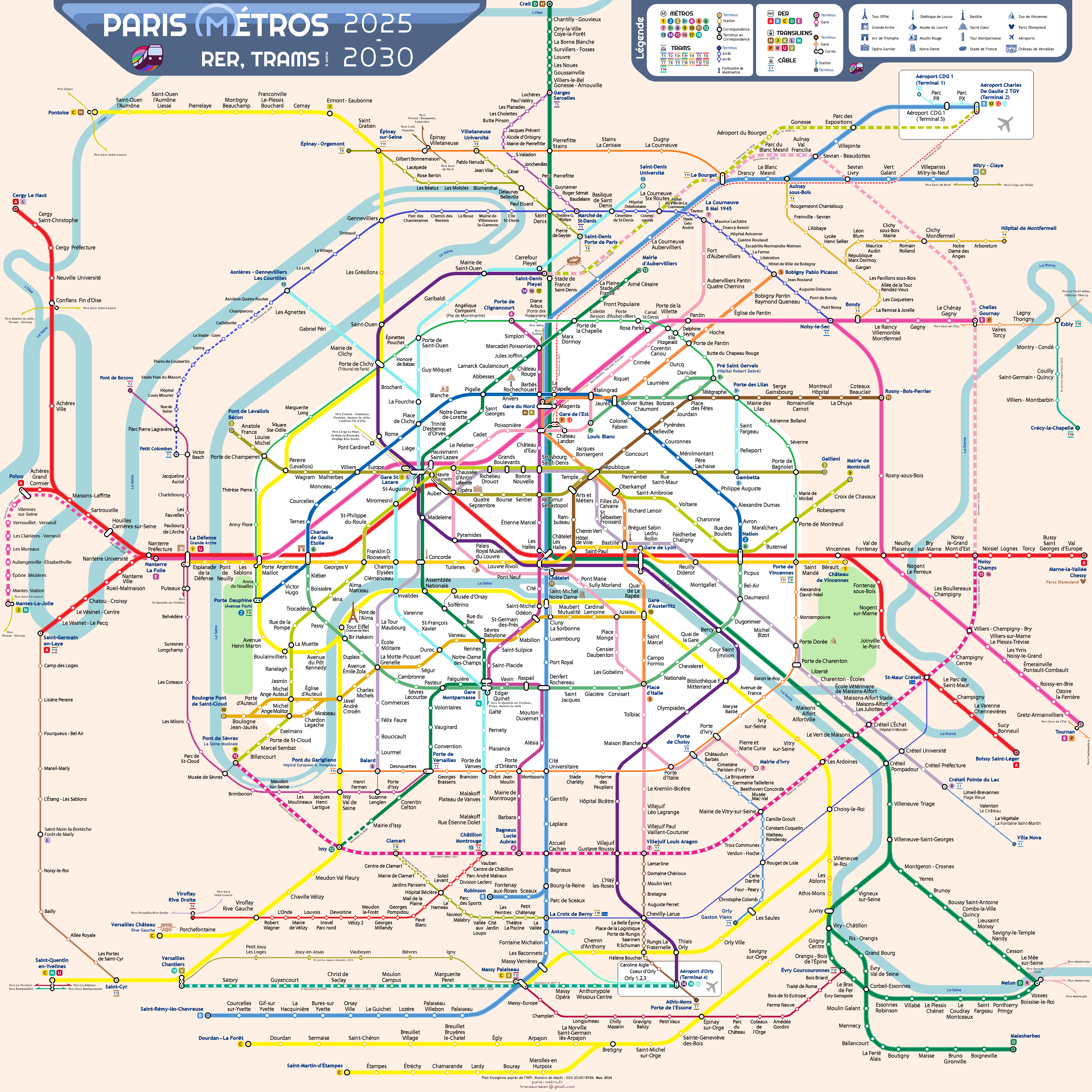
Lines 16, 17, and 18 stretch far into the suburbs and beyond, sometimes reaching the final stops of the RER. Meanwhile, trams are spreading across Île-de-France, weaving together a deeply transformed network. Paris itself is taking on a whole new look!
The metro is reaching further, connecting more, and creating tighter links with the RER and trams. This map follows the same ambition, reflecting the bold evolution of the transport network it represents!
A metro map completed by RER and trams, shared by all residents of Greater Paris.
A map that dares to finally align north-south and east-west axes vertically and horizontally!
Transversal routes and orbital lines are now clearly visible and instantly recognizable!
A map that takes on the challenge of both simplifying an extraordinarily complex network and making Paris even more recognizable to the Franciliens who navigate it daily.
A resolutely modern map, designed with 40° diagonals for optimal readability.
A map that aims to make Paris shine among the world’s great cities and inspire everyone to embrace its public transport system!


THE KEY STRENGTHS OF THIS NEW MAP OF PARIS METRO, RER, TRAMS, AND OTHER TRANSPORT:

  • It brings together, in just two versions, a single map for all residents of the Île-de-France region—whether suburban, inner-city Parisians, or those on the region’s outskirts.

  • It faithfully represents complex connections and allows users to instantly spot longer transfers (including those involving extended walking distances).

  • It organizes and simplifies an extraordinarily dense and extensive network.

  • It preserves the geographical landmarks cherished by lovers of Paris and its surrounding region.

  • It boldly adopts north–south and east–west axes—a logical and natural choice, yet unprecedented until now.

  • It makes it easy to identify these radial axes as well as ring routes at a glance.

  • It improves readability from a distance and at low resolution through a specially redesigned typeface.

  • Thanks to its square format, it integrates perfectly into infrastructure, onboard vehicles, and in stations.

  • It quickly familiarizes both daily commuters and occasional users with the network.

  • It encourages public transport use through visually clear and intuitive routes.

  • It highlights the freedom for users to explore the Paris metropolitan area and beyond.

  • It aims to enhance Paris’s global prestige and distinguish it from other major international cities.

  • It seeks to firmly establish itself within the unique history of the Paris metro map.


The first frenglish version of the Paris metro map !

La carte du métro de Paris pour la première fois en version franglaise !

See also: Transeurasien

Contact : neopurpink@hotmail.com

IL FAIT BEAU SUR PARIS-MÉTRO

Install Paris-métro
Install Paris-métro
Install
Later
Install Paris-métro
Press
icon
Choose "Home Screen
"
Press "Add"
Got it